

41.84 Acres Right on Route 66!
Apache County, Arizona

Get New Property Updates
You'll be the first to know of our newly listed properties before anyone else, along with exclusive discounts on land. Sign up for our VIP list and get $250 off your first property purchase.
We promise to never send you spam or flood your inbox. I agree to be contacted by Ashbrook Land Company via call, email, and/or text. (To opt out, you can reply 'stop' at any time or click the unsubscribe link in the emails. Message and data rates may apply, message frequency varies.) Privacy Policy & Terms
Property Summary
Your Address Can Be “Route 66”!
You can see incredible desert landscape for miles on this large 41.84 acre ranch in Apache County, AZ! This land lies right along Old Route 66, so access is a breeze. There are zero restrictions out here, so you’re only limited by your imagination! This expansive property would be a great place to start your own ranch or homestead. There’s plenty of acreage to use however you want, and it’s flat, making it a great place to build. And because it’s so easy to access from highway I-40, it would even be an ideal location for an RV campground! The possibilities are endless! Many of the parcels in Northeast Arizona can be difficult to reach, but not this one! Paved road access ensures that you’ll be able to reach your property anytime – even during the rainy times of the year when washes take out dirt and gravel roads.
- Great paved road access via Old Route 66, which runs right along the property border
- Very close to the Petrified Forest National Park – only a 15 minute drive away!
- Peaceful, flat location with desert landscape views on all sides
- About 20 minutes away from Holbrook, AZ
- NO covenants or restrictions – you’re free to do whatever you want!
- Only a quarter of a mile away from electric
Electricity can be found 1/4 mile down the road, making it easy to hook it up to the grid. If you’d rather stay off-grid, solar panels would work out great – there are, on average, 272 sunny days every year! This land lies over the Coconino Aquifer, so underground water is plentiful if you’d like to drill a well. Well depths in this area average around 100ft. Sewer would be by private septic system or an alternative.
This property is zoned as Agricultural-General so it is the least restrictive zoning possible. In addition, Apache County is very accepting of alternative living and green builds like earthships, rammed-earth homes, and tiny homes on wheels. Manufactured and mobile homes are allowed as well.
This area is perfect for outdoor adventurers! You’ll have plenty of room to explore your own land, and you’ll also be surrounded by the Petrified Forest National Park, where you can hike, camp, or just take in the incredible scenery. You can take a step back in time and drive down Old Route 66, or you can go about an hour south to visit the Sitgreaves National Forest. You’ll never run out of things to do or areas to explore!
You can drive to Holbrook, AZ in only 20 minutes. Not only will you find modern conveniences such as stores and restaurants, but the city also hosts several well-known, family friendly events throughout the year. Learn all about the rich history of the area at the Route 66 Festival, or take the kids to the Navajo County Fair & Rodeo! It’s only about an hour and a half away from Flagstaff, AZ, so you could easily take a day trip to experience outdoor adventures, historic hotspots, or just escape the desert heat. This land is also in the ideal spot for a commercial business. It’s easy to find and right off of highway I-40!
This large desert ranch is priced competitively at $38,400 for a cash sale. Owner financing is also available with a down payment of $2,880 and monthly payments of $680 for 72 months ($51,840 total). See the "Pricing" section below to secure this property now with only $500!
Boundaries in drone photos and video are *approximate* for visual purposes only. Actual boundaries may vary.
At Ashbrook Land Company we perform in-depth, extensive research into all of our properties before listing them, but it is ultimately the buyer's responsibility to perform their due diligence before purchase. The information provided on this page is, to the best of our knowledge, correct, and is deemed reliable but not guaranteed. All prospective buyers are encouraged to contact the county to confirm legality or feasibility of any future development plans. Rural, undeveloped land can be dangerous due to terrain, weather, and poor or non-existent road access and calls for caution when visiting. Ashbrook Land Company will not be held responsible for any action or outcomes by visitors to a property of ours. We make no warranties or representations about the land, its condition, or what can be built on the property.
Property Details
- address
- TBD Old Route 66
- city
- Sanders Unified District
- state
- Arizona
- zip
- 86028
- county
- Apache
- parcel id
- 211-50-002
- access
- Legal and physical access via Old Route 66
- zoning
- Agricultural General: the Agricultural General Zone, certain uses are automatically permitted, such as residential homes, general agricultural uses such as raising livestock, and farming, and limited commercial uses so long as the property is along a public thoroughfare. Some uses must be approved through a Conditional Use Permit. Please see the Apache County Zoning PDF file for full zoning use allowances.
- property owners association
- None
- camping
- RV and tent camping is allowed. If RV camping longer than 30 days, the RV must be hooked up to a permitted septic system.
- hunting
- Allowed on the property, with a hunting license/tag.
- terrain
- High desert trees and shrubs; trees are juniper and pinon pine.
- grade
- Level
- elevation
- 5560 ft
- power
- Off-grid, but power is along Route 66.
- water
- Off-grid, you would need to drill a well. This property lies above the Coconino Aquifer, which provides plenty of underground water. Well depths in this area average around 100ft.
- sewer
- Off-grid, would require septic or alternative
- property taxes
- $36.18 (in 2021)
- conveyance
- Free and clear warranty deed
- gps coordinates
- Center: 35.0234, -109.8364
- google maps link
- https://goo.gl/maps/Xx7gAMLSHg3Pv41M8
Files
- Apache County Agricultural-General Zoning.pdf
- Apache-County-Zoning-Ordinance.pdf
- FAQ-Building-Safety.pdf
- Requirements-Unconventional-Green-Construction.pdf
- Tiny-House-requirements.pdf
- Want-to-Build-A-House.pdf
- Work-that-does-not-require-a-building-permit.pdf
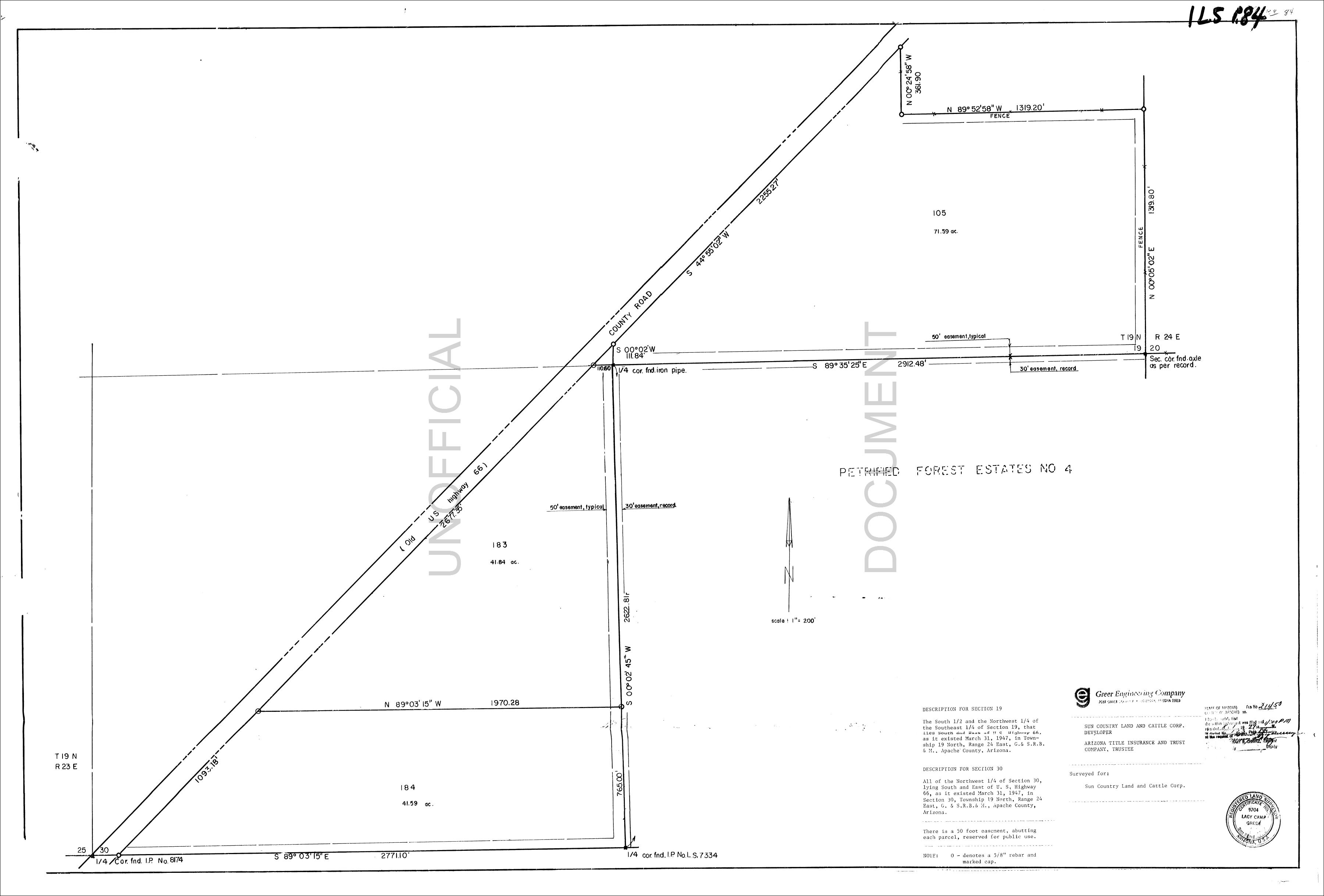
- Survey Map.jpg
Property Photos

Property Map
Visit The Property
Get this interactive map sent to your smartphone so that you can use your phone’s GPS to find the property and walk the boundaries.
- Download the MapRight App onto your smartphone.
- Click this link in your phone's browser.
- Click the “Open in iOS” or “Open in Android” button.
Rachel made the entire land purchase a "piece of cake". She walked me through everything and was right on top of things. As soon as I sent the money, the deed was notarized and recorded only a couple of days later. I just visited my new property in Wolf Creek Montana today and I am very pleased with the purchase. Thank you again 😊
I just purchased a piece of land from Ashbrook Land Co., LLC, and I am very happy with the professional yet personal approach that Bob and Rachel Ashbrook gave to me.The whole process was easy and painless, and only took a couple of days. Everything was done online, but I felt completely secure giving out my personal information, because I think the Ashbrooks are truly honest people to deal with.
Sean and Rachel made the decision to purchase land EASY! Their communication skills are amazing! Their replies are prompt, all the necessary information regarding the property was provided.