

160 Acres Next to the Petrified Forest NP!
Navajo County, Arizona
Get New Property Updates
You'll be the first to know of our newly listed properties before anyone else, along with exclusive discounts on land. Sign up for our VIP list and get $250 off your first property purchase.
We promise to never send you spam or flood your inbox. I agree to be contacted by Ashbrook Land Company via call, email, and/or text. (To opt out, you can reply 'stop' at any time or click the unsubscribe link in the emails. Message and data rates may apply, message frequency varies.) Privacy Policy & Terms
Property Summary
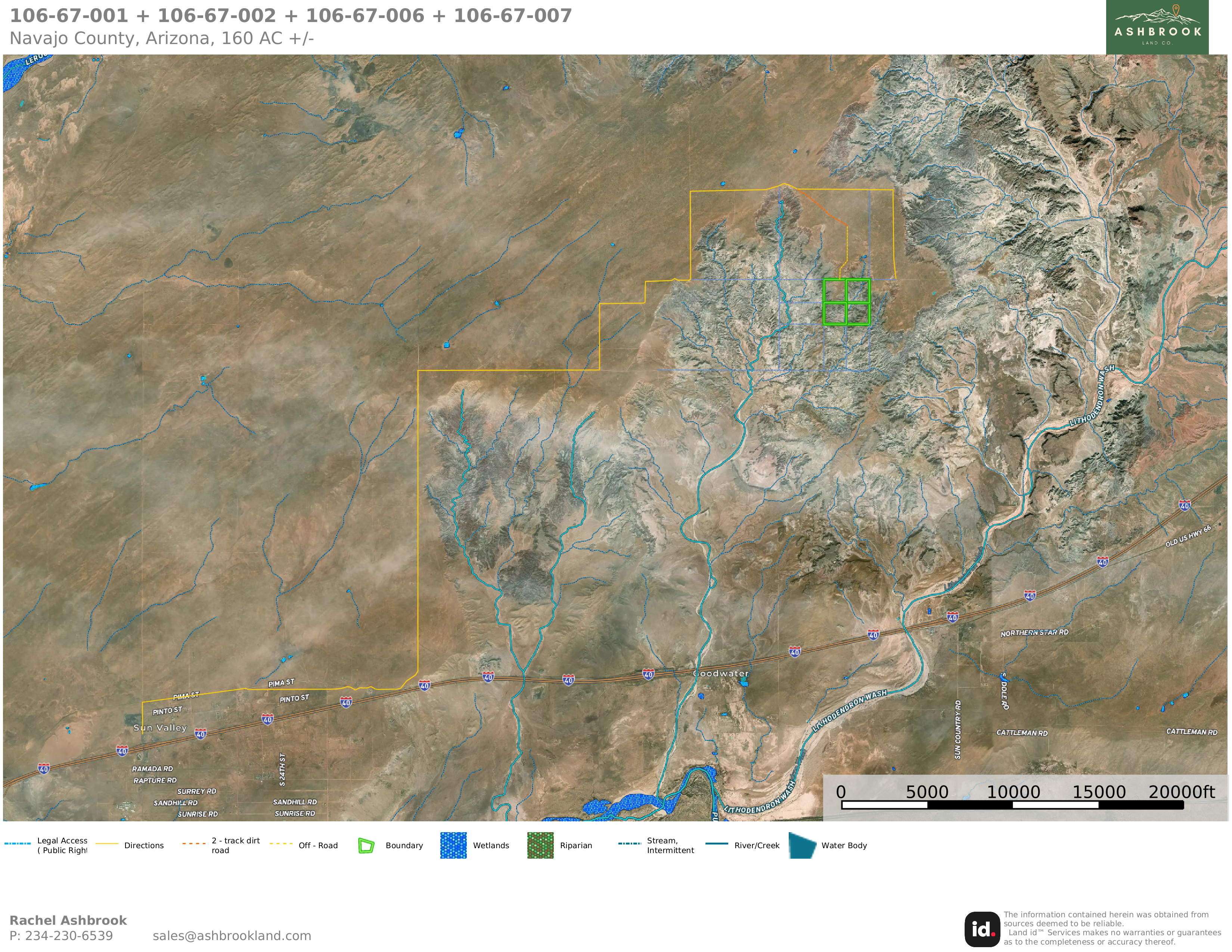
This 160 acres in Northern Arizona is an INCREDIBLE recreational property with astounding views of the painted rock badlands from an elevated perspective. This type of property comes up once in a lifetime.
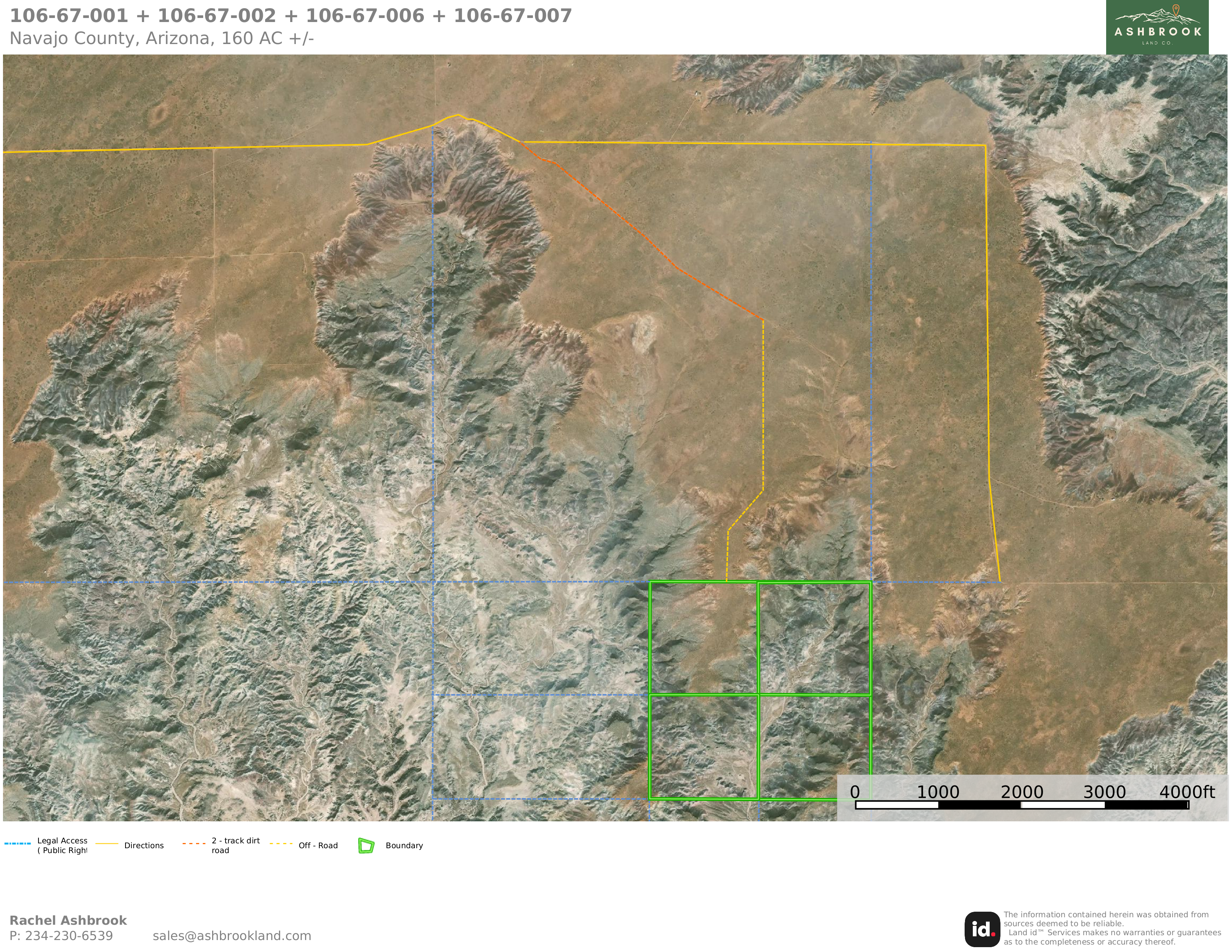
The northwest corner has a mesa, which would be a great spot to set up camp. You can’t beat the views of the Painted Desert from that elevation! Most of the land is comprised of badlands terrain, with remarkable geologic formations, boulders, and dry river beds which fill up during heavy rains. This really is an ATV lover’s paradise with the best of all worlds with regard to gorgeous vistas, solitude, and plenty of land to explore on a daily basis. A seasonal wash cuts through the eastern half of the property. You can even explore the public land that borders to the north and the east. The Petrified Forest National Park lies one parcel away to the east, giving you even more opportunities for outdoor adventures!
- No restrictions
- Borders public land on 2 sides
- Agricultural-General zoning
- Badlands with opportunities for fossil hunting and petrified wood
- Seasonal streambed cuts through the eastern half of the property
This is a true desert oasis and a wonderful location for an off-grid hideout, campground, or retreat of any sort that you can dream up. You can use solar panels or a generator for electricity, or keep it completely off-grid. For water, you can haul your own or drill into the plentiful groundwater supplied by the Coconino Aquifer.
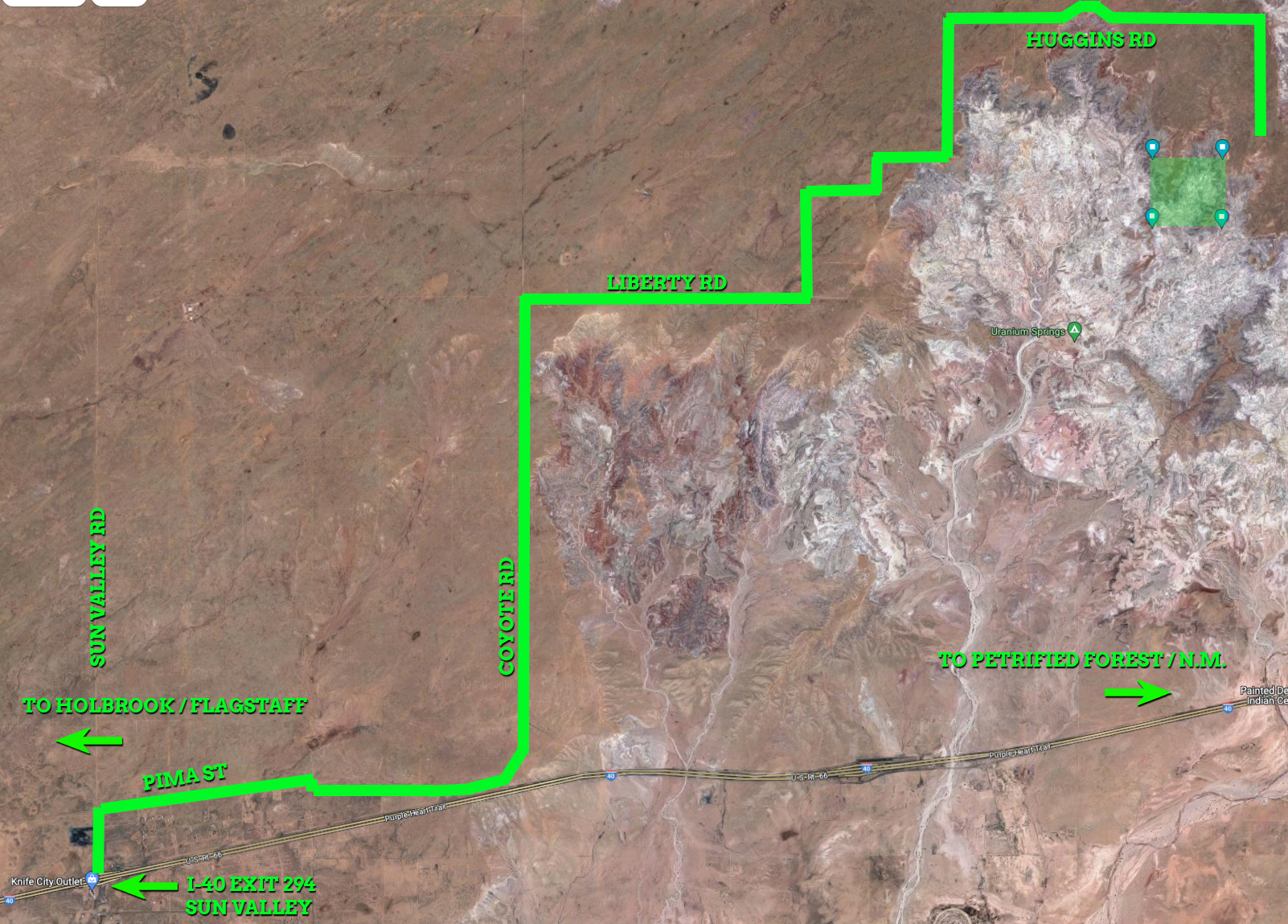
A slight elevation in the northwest corner of the property offers a perfect perch for you to experience stunning views for miles around. The unique landscape offers an unparalleled escape from normality. For example, taking advantage of this landscape a few miles away is a Mad Max-style campground called "Uranium Springs," which hosts a few yearly festivals to create a post-apocalyptic scene, getting you "way beyond the pale of civilization" and into a whole different world. It's an "artistic convergence" unlike anywhere else.
This land is about 30 minutes away from the freeway and a quick drive to the city of Holbrook, which has plenty of supplies and amenities. It is bordered by private land on two sides, and there is insured legal access to the property via easements along all property lines in this area. A road can be bladed along any of these public access easements; the most direct route would be from Huggins Road, which is approximately 1/4 mile directly east of the NE corner.
Another way to visit the property would be via the route highlighted by the turn-by-turn directions found in our “Files” section, which utilizes a current two-track trail and an off-road overland route through the AZ State Land to the north. This route is not considered legal access but the public land may be utilized for recreational use. You would need a recreational permit to use this AZ State Land recreationally; the permit is easy to obtain here and costs $15-20 per year. If this route is one that you would like to use as a permanent, legal right-of-way, you may apply for a right-of-way from the AZ State Land Department.
We provide a detailed LandID map to help understand legal and physical access points (see the "Map" section and scroll your cursor over any line marked on the LandID map to see the description of the line.) We can also provide a plat map and direct you to Navajo County's GIS map to help as well. Please do your research to understand legal and physical access routes.
Don’t miss out on your chance to own this once-in-a-lifetime desert playground! See the "Pricing" section below to secure this property now with only $500! Owner financing is also available; please contact us for terms.
At Ashbrook Land Company we perform in-depth research into all of our properties before listing them, but it is ultimately the buyer's responsibility to perform their due diligence before purchase. The information provided on this page is, to the best of our knowledge, correct, and is deemed reliable but not guaranteed. All prospective buyers are encouraged to contact the county to confirm legality or feasibility of any future development plans. Rural, undeveloped land can be dangerous due to terrain, weather, and poor or non-existent road access and calls for caution when visiting. Ashbrook Land Company will not be held responsible for any action or outcomes by visitors to a property of ours. We make no warranties or representations about the land, its condition, or what can be built on the property.
Property Details
- address
- TBD Near Huggins Rd
- city
- Holbrook
- state
- Arizona
- zip
- 86029
- county
- Navajo
- parcel id
- 106-67-001 + 106-67-002 + 106-67-008 + 106-67-007
- subdivision
- Painted Desert Ranches
- access
- Legal access via easements along property boundaries (please see the maps in our "Files" section below)
- zoning
- Agricultural General: Uses permitted in the "A-General Zone", include farm and non-farm residential uses, farms, recreational, institutional, commercial and industrial uses as specifically listed. Please see the Navajo County Zoning PDF file for full zoning use allowances.
- property owners association
- None; no restrictions on use beyond County Zoning
- camping
- Tent and RV camping are allowed for 30 days once per year without needing a Recreational Vehicle Permit. A permit may be obtained for temporarily placement of an RV for one year and renewed once.
- hunting
- Allowed with the appropriate tags/licenses
- terrain
- Badlands with a seasonal streambed along the eastern half of the property
- grade
- Gently rolling
- elevation
- 5640 ft
- power
- Off-grid, would require solar panels or another alternative.
- water
- Off-grid, you would need to drill a well. This property lies above the Coconino Aquifer, which provides plenty of underground water. Water levels in this area average around 485 ft.
- sewer
- Off-grid, would require septic or alternative.
- property taxes
- $246.64 (in 2022)
- conveyance
- Free and Clear Warranty Deed
- gps coordinates
- Center: 35.0514, -109.9202, Northwest Corner: 35.0552, -109.9246, Northeast Corner: 35.0551, -109.9157, Southeast Corner: 35.048, -109.9157, Southwest Corner: 35.048, -109.9246
- google maps link
- https://goo.gl/maps/N6weGpEBETrrtgQr7
Files
Property Photos


Property Map
Visit The Property
Get this interactive map sent to your smartphone so that you can use your phone’s GPS to find the property and walk the boundaries.
- Download the MapRight App onto your smartphone.
- Click this link in your phone's browser.
- Click the “Open in iOS” or “Open in Android” button.
Rachel made the entire land purchase a "piece of cake". She walked me through everything and was right on top of things. As soon as I sent the money, the deed was notarized and recorded only a couple of days later. I just visited my new property in Wolf Creek Montana today and I am very pleased with the purchase. Thank you again 😊
I just purchased a piece of land from Ashbrook Land Co., LLC, and I am very happy with the professional yet personal approach that Bob and Rachel Ashbrook gave to me.The whole process was easy and painless, and only took a couple of days. Everything was done online, but I felt completely secure giving out my personal information, because I think the Ashbrooks are truly honest people to deal with.
Sean and Rachel made the decision to purchase land EASY! Their communication skills are amazing! Their replies are prompt, all the necessary information regarding the property was provided.