

74+ Acres with Public Land on 2 Sides!
Apache County, Arizona
Get New Property Updates
You'll be the first to know of our newly listed properties before anyone else, along with exclusive discounts on land. Sign up for our VIP list and get $250 off your first property purchase.
We promise to never send you spam or flood your inbox. I agree to be contacted by Ashbrook Land Company via call, email, and/or text. (To opt out, you can reply 'stop' at any time or click the unsubscribe link in the emails. Message and data rates may apply, message frequency varies.) Privacy Policy & Terms
Property Summary
This large off-grid 74+ acre wooded ranch in Northeast Arizona borders public lands and has great road access.
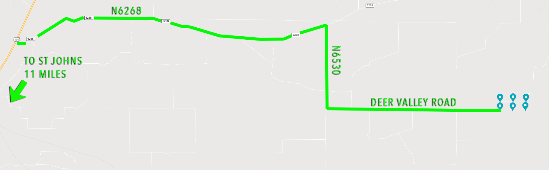
- 74+ acres in Woodland Valley Ranch. Two side-by-side lots.
- Excellent dirt road access maintained by WVR and bladed yearly.
- A water well is available to property owners for water hauling up to 500 gallons/week.
- Borders a section of BLM land to the south and a section of AZ State Trust land to the west.
Please note: the property boundaries in the aerial photos are approximate and may vary slightly from actual property markers.
This ranch consists of two side-by-side parcels, each about 37 acres. The topography is nearly level allowing many ideal building sites, but also has gentle rises to give sweeping views of the surrounding mountains and valleys. It is covered with a mixture of open meadowland and brush but also wooded with juniper trees. This property allows you the space and freedom to live life the way you want. With close proximity to the town of St. Johns, you’ll enjoy the quiet serenity of the countryside with only a quick drive to town when you need supplies.
Situated around 6,200 ft elevation in northeastern Arizona, you'll enjoy ideal weather all year round. The winters are very mild and sunny (the average high temp in January is 50 degrees) and the summer highs average in the upper 80s, with cooler nights and monsoon rains. These summer rains bring out the flowers and lush grasses. This climate is perfect to raise livestock or horses. Resident wildlife in this area include antelope, elk, deer and an abundance of bird life. This parcel borders BLM land to the south and AZ State Trust Land to the west which acts as an extension of the property and allows access to hunting, camping, and endless exploring.
There is an abundance of water in the area for sustainable living. This property lies over the massive Coconino aquifer to provide water to your private well. Alternatively, Woodland Valley Ranch maintains a convenience well so that property owners can have free access to water hauling, which is great to have for camping, living off-grid, or to use before drilling a well of your own. There is a 500 gallon/week limit per property owner. The POA has a few very mild covenants which help keep the area a quiet, secluded residential and recreational ranching community. In summary, you can build any type of home you want, raising livestock is allowed (with the exception of swine), and camping, Tiny Homes and RVing are welcome. Please see the CCRs document under the "Files" section of this page.
At Ashbrook Land Company we perform extensive research into all of our properties before listing them, but it is ultimately the buyer's responsibility to perform their due diligence before purchase. The information provided on this page is, to the best of our knowledge, correct, and is deemed reliable but not guaranteed. All prospective buyers are encouraged to contact the county to confirm legality or feasibility of any future development plans.
Property Details
- address
- TBD N6600
- city
- St. Johns
- state
- Arizona
- zip
- 85936
- county
- Apache
- parcel id
- 204-62-639 (37.76 acres) and 204-62-640 (37.08 acres)
- subdivision
- Woodland Valley Ranch, Lots 639 and 640
- access
- Direct access via well-maintained dirt road
- zoning
- Agriculture-General. Recreational, residential, and personal farms/ranches are permitted. A reasonable number of livestock are allowed, but no swine and farming/ranching must not be for commercial purposes. Tiny homes are permitted with a minimum size of 200 sqft.
- property owners association
- Woodland Valley Ranch POA provides roadway repair and maintenance along with a convenience water well. Dues are $15/month per parcel, subject to future adjustment. Roads are bladed once per year. The POA determines the cost of roadway repair once per year, and landowners are charged on a per acre basis. There is a CONVENIENCE well located in the north east area of the ranch. It is for the convenience of the POA members only and subject to rules of use. There is a 500 gallon per week limit PER PROPERTY OWNER (subject to change). There are no carry-overs from week to week. If more than one person or a business owns property (regardless of the number of lots owned) at WVR, it still counts as a single owner. Water from the well is intended for household use. Hunting is prohibited. Main roads are bladed once per year.
- camping
- Allowed. If camping longer than 30 days, RV must be connected to a permitted septic system.
- hunting
- Not permitted in Woodland Valley Ranch, however it is allowed on the adjoining public lands with a proper permit.
- terrain
- High desert terrain with mature pinon pine, juniper trees, along with a mix of grassy open meadow and shrubs.
- grade
- Nearly flat/gently undulating
- elevation
- 6,280 ft
- power
- Off-grid, would require solar power, generator, or alternative source.
- water
- Would require well or water hauling/cistern. Well depths in the area range from 100-700ft deep into the Coconino Aquifer. There is a convenience well available to property owners who may haul 500 gallons/week from the well.
- sewer
- Would require septic system or alternative.
- property taxes
- Lot 639: $88.16/year, Lot 640: $88.90/year (2021 taxes)
- conveyance
- Free and clear warranty deed, insurable title.
- gps coordinates
- Northwest Corner: 34.6322, -109.1024; Northeast Corner: 34.6322, -109.0922; Southeast Corner: 34.6291, -109.0922; Southwest Corner: 34.629, -109.1024
- google maps link
- https://goo.gl/maps/CKEthHunN6766AqD8
Files
- Woodland Valley Ranch Map.pdf
- Woodland Valley Ranch Survey (Pg 1).pdf
- Woodland Valley Ranch Survey (Pg 7).pdf
- Woodland Valley Ranches CC&Rs.pdf
- MAP.jpg
- FAQ-Building-Safety.pdf
- Requirements-Unconventional-Green-Construction.pdf
- Work-that-does-not-require-a-building-permit.pdf
- Apache County Agricultural-General Zoning.pdf
- Apache-County-Zoning-Ordinance.pdf
Property Photos


Property Map
Visit The Property
Get this interactive map sent to your smartphone so that you can use your phone’s GPS to find the property and walk the boundaries.
- Download the MapRight App onto your smartphone.
- Click this link in your phone's browser.
- Click the “Open in iOS” or “Open in Android” button.
Rachel made the entire land purchase a "piece of cake". She walked me through everything and was right on top of things. As soon as I sent the money, the deed was notarized and recorded only a couple of days later. I just visited my new property in Wolf Creek Montana today and I am very pleased with the purchase. Thank you again 😊
I just purchased a piece of land from Ashbrook Land Co., LLC, and I am very happy with the professional yet personal approach that Bob and Rachel Ashbrook gave to me.The whole process was easy and painless, and only took a couple of days. Everything was done online, but I felt completely secure giving out my personal information, because I think the Ashbrooks are truly honest people to deal with.
Sean and Rachel made the decision to purchase land EASY! Their communication skills are amazing! Their replies are prompt, all the necessary information regarding the property was provided.